
Lot n° 12
Estimation :
18000 - 20000
EUR
Résultats sans frais
Résultat
: 19 000EUR
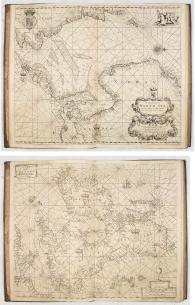
SELLER, J.
The Coasting Pilot : describing the Sea- Coasts ... of England, Holland, Flanders & France. Londres, ca. 1701. In-folio de (1) f. de titre, 40 pp. et 13 cartes ; veau brun, plats ornés d'un motif central rectangulaire de filets à froid encadrant un compartiment en veau fauve (reliure de l'époque). Coiffe sup. fendue avec petit manque. Infimes rousseurs et pâles mouillures. Bel exemplaire. - Folio, full contemporary calf. With 13 double page engraved charts. pp. 40. With the usual paper discoloration and slight staining Binding a little bit used. Generally in fine condition. 457 x 295 mm. (R) AN UNRECORDED "COASTING PILOT", published by Jeremiah Seller & Charles Price. The title page of this maritime atlas reads : "The Coasting Pilot... Collected and published by John Seller. Printed for Jer : Seller and Cha : Price Hydrographers at y Hermitage Stairs in Wapping.". John Seller Sr. (d.1697) is one of the most important figures in the early history of the map and chart-publishing trade in England. He was the first Englishman to try establish an atlas-publishing business comparable with continental firms, such as Blaeu, Janssonius, de Wit, Goos, Colom & Doncker. Jeremiah Seller (1675-1720) was the son of John Seller, and was also a mapmaker, instrument- maker and publisher. Jeremiah Seller and his partner, Charles Price, were "Hydrographers to ye Queen" and "Compass makers to the Navy Royall.", their partnership ended in bankruptcy in 1706. In partnership with Price, Jeremiah published in 1701 "The Fifth Part of the General English Pilot ...". The atlas includes charts with the addresses of "John Seller Hydrographer to the King" and by "Jer: Seller & Cha: Price." Contents : 1) A Plat of the Channel ; Discovering the Sea Coast of England, Scotland, Ireland and Part of France. Newly corrected ; (Address erased) ; London. 2) A Chart of North Sea / By Jer: Seller & Cha : Price ; at the Hermitage Stairs in Wapping. 3) A Chart of the Sands, Shoals, Buoys Beacons & Sea-marks ;
Mes ordres d'achat
Informations sur la vente
Conditions de vente
Retourner au catalogue